Air masses constantly circulate in the atmosphere. Their names correspond to the place on the map where they were formed. Air masses are continental (formed over land) and marine (formed over water). They put pressure on the surface of the earth and on all the creatures that inhabit it. This impact varies in strength. An area of low pressure in the atmosphere is a storm or cyclone. However, this applies to measurements on a surface related to sea level. In the mountains, an area of low pressure characterizes the normal state of the atmosphere. This is a common occurrence here.
Atmosphere pressure
An area of low pressure in the atmosphere is a relative indicator.
It should be considered as a parameter measured above sea level. In this case, a value of 765 mmHg is considered normal. The higher the altitude of the measurements made, the lower the emerging areas of atmospheric pressure become. At the border of snow caps in the mountains, this indicator is considered normal at a value of 350 mm Hg.
Thanks to this, the concept of areas of low atmospheric pressure is considered from the point of view of the indicator and the surrounding air masses. For each area where they were formed, the characteristic features affecting circulation are determined. Determining the weather in a particular region is always correlated with studies of all natural phenomena that occur in the region.
Patterns in changes in atmospheric pressure and how to use this knowledge
Almost the entire mass of the Earth's atmosphere is concentrated in a layer up to approximately 50 km high. Upon reaching an altitude of 50 km, the acceleration due to gravity decreases by only 1.5% compared to the acceleration at sea level; therefore, we can assume that within the entire 50-kilometer layer of the atmosphere, the acceleration of gravity remains equal to g = 9.8 m/s2.
Representing atmospheric air as a continuous medium, we, of course, must not forget that in reality it is a gas. Pressure is a statistical quantity expressed through the square of the speed of their chaotic movement averaged over many molecules. The force of pressure on any real or mentally selected area in a gas is due to the chaotic bombardment of this area by many molecules.
Pressure decreases with altitude and increases when descending into deep mines. The reason is the rarefaction of air (decrease in density) with ascent and compaction with descent, because it is attracted by the earth and the bulk of its mass is concentrated around it. In the lower troposphere, pressure decreases with altitude by approximately 1 mm for every 10.5 m. This makes it possible to determine the height of a place using a barometer-altimeter.
How does atmospheric pressure change with altitude?
In fact, this pattern is observed only up to a height of 1 km. The distance in meters that one must rise or fall in order for the atmospheric pressure to change by 1 mb is called pressure level . The pressure level at an altitude from 0 to 1 km is 10.5 m, from 1 to 2 km – 11.9 m, at an altitude of 2-3 km the pressure level is 13.5 km. The pressure level depends on the temperature. It is greater in warm air. The barometric formula is described more precisely here: https://ru.wikipedia.org/wiki/
In practice, special tables are often used that allow more or less approximately obtaining data on heights. But to solve problems that do not require high accuracy, you can also use the average value. You can estimate the pressure from the difference in height, and calculate the height from the difference in pressure.
Problem 1
Climbers climb a mountain whose height is 5100 m. At the foot of the mountain, the pressure is 720 mm Hg. Art. What pressure will there be at the top?
Solution:
When ascending 10.5 m, the pressure decreases by 1 mmHg. Art.
1) Find out how many mm. rt. Art. The pressure will decrease when climbing this mountain. 5100:10.5=486 (at 486 mmHg)
2) Find out what the pressure will be at the top. 720-486=234 (mm Hg)
Answer: At the top there will be a pressure of 234 mmHg. Art.
Problem 2
Determine at what altitude the plane flies if the pressure outside is 450 mm Hg. Art., and at the surface of the Earth 750 mm Hg. Art.
1) Determine the difference in pressure. 750-450=300 mm Hg. Art. - the plane rose 10.5 meters so many times.
2) Find out how many meters the plane rose. 10.5 X 300 = 3150 (m)
Answer: the plane is at an altitude of 3150 m.
Problem 3
At the foot of the hill, the barometer shows pressure - 761 mm Hg. Art., and at the top - 761 mm Hg. Art. What is the height of the hill?
The problem is solved according to the same principle as the previous one.
1) 761-750=11 (mm Hg)
2) 11 X 10.5 = 115.5 (m)
Answer: the height of the hill is 115.5 m.
Air circulation
The formation of areas of low atmospheric air pressure is associated with the process of its circulation.
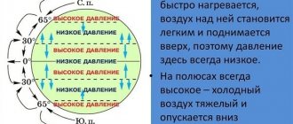
It occurs due to the tilt of the earth's axis and the heterogeneity of heating of the planet at the equator and poles. An area of low atmospheric air pressure is formed due to high temperatures at the equator. When heated, it expands and rises. And given the fact that the opposite effect occurs at the poles and increased pressure occurs, air masses circulate.
Moreover, if low pressure forms in one area, then high pressure will certainly form in another.
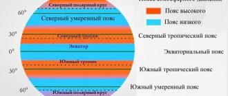
Atmospheric circulation . The system of air movement over continents and oceans under the influence of solar energy is called atmospheric circulation . As a result of uneven heating of the earth's surface, as well as the influence of the deflecting force of the Earth's rotation around its axis, belts with different atmospheric pressure are formed. Air moves from zones with higher atmospheric pressure to zones with lower atmospheric pressure. This is the main reason for atmospheric circulation.
It must be taken into account that atmospheric pressure belts can shift according to the seasons of the year. This is influenced by differences in the heating of continents and oceans.
In summer, continents warm faster and more than oceans; warm light air rushes upward, creating a rarefied space above the surface of the continent - the pressure decreases. Therefore, air moves from the oceans, where there is higher pressure, to land, where there is low pressure. In winter, on the contrary, the land cools faster, but the ocean remains warmer for a long time, and air moves from land to sea. It should also be noted that the Northern Hemisphere heats up more in summer and less in winter. Therefore, pressure belts shift north in summer and south in winter. This is also reflected in the movement of air between the belts.
In equatorial latitudes, due to high solar radiation throughout the year, the pressure is always low. This is explained by the fact that the air heated from the earth's surface above the equator constantly rises (upward air currents) and spreads north and south of the equator towards tropical latitudes. Due to the rotation of the Earth around its axis, moving air is deflected to the east. In the upper layers of the troposphere at an altitude of 10-12 km, it gradually cools. Over the tropics between 20¨ and 30¨ n. and Yu. w. The air that has cooled at altitude begins to descend (downward air currents). Therefore, in tropical latitudes, the air, descending, forms increased pressure in the ground layer (near the surface). Here throughout the year there are continuous belts of high pressure.
In the polar latitudes, over the glaciers of Antarctica and Greenland, and the drifting ice fields of the Arctic, low air temperatures and high pressure are observed throughout the year (the air is cold and heavy).
Rice. 10. General scheme of atmospheric circulation
From high pressure belts (tropical and polar latitudes), air at the Earth's surface moves to moderate latitudes. Here it heats up and rises. As a result, low pressure belts form in the temperate latitudes of both hemispheres.
Thus, the distribution of atmospheric pressure over the earth's surface has a pronounced zonal character. Belts of low (equatorial and temperate) and high pressure (tropical and polar) are formed on Earth The emerging pressure belts cause the movement of air at different latitudes, over land and sea, and determine the general circulation of the atmosphere (Fig. 10).
Constant and seasonal winds. The distribution of high and low pressure belts on Earth causes the occurrence of constant winds - trade winds, westerly winds of moderate latitudes, polar eastern winds, seasonal winds - monsoons.
Winds of tropical latitudes. Trade winds are winds that blow all year round mainly over the ocean from the tropics of the Northern and Southern Hemispheres to the equator, that is, from an area of high pressure to an area of low pressure (see Fig. 10). Under the influence of the Earth's rotation around its axis, the trade winds deviate in the Northern Hemisphere to the right, i.e., they blow from northeast to southwest, and in the Southern Hemisphere they deviate to the left and are directed from southeast to northwest.
Winds of temperate latitudes. From tropical high-pressure belts, air flows not only to the equator, but also to temperate latitudes, where low pressure predominates. Due to the rotation of the Earth, air currents gradually deviate to the east. So they acquire a predominantly western direction. Such winds, which act constantly, are called westerly winds . They intensify in winter and provide westerly air transport throughout the year.
Winds of the polar regions. In the polar regions of the Earth, air moves from the polar high pressure areas towards the low pressure of the temperate latitudes. These are the predominant northeast winds in the Northern Hemisphere and southeast winds in the Southern Hemisphere. Under the influence of the Earth's rotation, the winds intensify and take the eastern direction (where they blow from) and contribute to the general eastern transfer of air. Antarctic winds, unlike Arctic ones, are stable and have high speeds.
Seasonal winds. The constantly operating general circulation of the atmosphere is disrupted by seasonal circulation. Unlike constant winds, seasonal air movement is associated with meridional air movement and is caused by temperature differences between land and sea and unequal pressure above them. Such seasonal winds, changing their direction twice a year, are called monsoons . The summer monsoons blow from cool, high-pressure oceans onto warm, low-pressure continents. They bring cool, moisture-rich air and cause precipitation. The winter monsoon blows from continents with high pressure to the ocean with low pressure. It carries cold and dry air, partly cloudy dry weather (Fig. 11). The effect of extratropical monsoons manifests itself in the eastern parts of the continents, where they are adjacent to vast expanses of oceans (in the Russian Far East, Japan, Alaska). (Find on the atlas map the areas of influence of the trade winds, westerly winds, polar eastern winds, and monsoons.)
In the Earth's tropical latitudes, monsoons are associated with differences in winter and summer temperature and pressure between the Northern and Southern Hemispheres. They contribute to the exchange of air between the hemispheres (Tropical Africa north of the equator, East Africa south of the equator, Hindustan, Indochina, Eastern China, etc.).
Rice. 11. Formation of summer and winter monsoons
Rice. 12. Distribution of precipitation amounts depending on the latitude of the area
Distribution of precipitation on Earth. Atmospheric precipitation on the earth's surface is distributed unevenly (Fig. 12). The main reasons for the uneven distribution of precipitation are air temperature and general atmospheric circulation. The distribution of precipitation on Earth also depends on the position of the territory relative to the World Ocean, the proximity of warm or cold currents, and relief. (Study the factors of precipitation distribution on the globe.)
Air temperature and general atmospheric circulation determine zonal precipitation.
The equatorial belt by maximum precipitation - up to 2000 mm per year. On the slopes of some mountains, up to 6000-7000 mm falls, and, for example, on the slopes of the Cameroon volcano (Africa) - 10,000 mm. The large amount of precipitation is due to high humidity, as well as the dominance of rising air currents, which favor the formation of clouds. The absolute maximum precipitation occurs in the foothills of the Himalayas (Cherrapunji - 12,000 mm).
Tropical zones receive the least amount of precipitation per year (100-250 mm). These are the Sahara, the deserts of Arabia, Western Australia and other areas of the globe. The minimum amount is typical for the Atacama Desert (0.01 mm). The western coasts of the continents, washed by cold currents (Peruvian, Californian, Benguela, Western Australian), are especially poor in precipitation. The eastern coasts of continents in the tropics (Florida, southeastern parts of Asia and Africa, Eastern Australia) are irrigated by rain brought by trade winds and monsoons.
In temperate latitudes , under conditions of low atmospheric pressure, the amount of precipitation increases. A significant amount of precipitation in the temperate latitudes of the Northern Hemisphere is associated with westerly winds. However, there are differences due to the large area of the continents. In the west (Western Europe, northwestern North America, western slopes of the Andes), under the influence of marine air masses, precipitation reaches 2000-3000 mm or more. In the central part, precipitation ranges from 600 mm in the west to 300 mm in the east. In monsoon areas (eastern coasts of North America and Eurasia), the amount of precipitation increases to 1000 mm.
Cold regions of polar latitudes in both hemispheres are characterized by low precipitation (less than 250 mm). The main reasons are weak solar radiation, low air temperatures, and insignificant evaporation.
Throughout the Earth, 520 thousand km3 of precipitation falls annually. Of these, 79% are over the oceans and 21% over land. In the region of the equator there is a lot of precipitation, almost half of all precipitation on Earth. In the tropical and polar zones ( in areas of high pressure) there is little precipitation - most of the tropical and arctic deserts of the globe are located there.
Bibliography
1. Geography 8th grade. Textbook for the 8th grade of general secondary education institutions with Russian as the language of instruction / Edited by Professor P. S. Lopukh - Minsk “People's Asveta” 2014
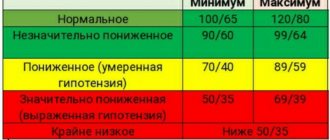
Definition of a cyclone
An area of low pressure in the atmosphere is a cyclone. It manifests itself in the form of a storm or even a tornado. In the center of the cyclone the pressure is much lower than at the edges.
If it formed in the northern hemisphere, the movement of air masses will occur counterclockwise. On the southern side of the planet it is the other way around. The Coriolis force moves the cyclone to the right, and in the south - to the left.
The area of low atmospheric pressure where a tornado or storm forms is initially located above the water surface. Therefore, this natural phenomenon brings with it rainy, cloudy weather. Frequent gusts of wind are caused by the difference in pressure in the center and periphery of the cyclone. An area of low atmospheric air pressure is formed with summer rains and cold snaps, and in winter with thaws and snowfalls. The air moves from the edge of the cyclone to its center, where it rises and cools.
Give a description of all climate zones!
Equatorial belt. Equatorial air masses (EA) all year round, low pressure zone. Climatic regions within the belt are not expressed. Temperatures are high all year round, there is excessive moisture, and there is a lot of precipitation. Seasonal fluctuations in average monthly temperatures, pressure and precipitation are insignificant, winds are weak. Weather: hot sunny before noon, heavy rain in the afternoon. Subequatorial belts. Seasonal change of air masses: in summer - equatorial (EQ), in winter - tropical (TV). In summer, the climatic and weather conditions are the same as in the equatorial zone, in winter - as in the tropical, desert climate region (kTV). Winter is slightly cooler than summer, but is dry. Tropical zones. Tropical air masses all year round (TA), predominance of continental tropical air (CTA). The pressure is high, the temperature is high, but in winter it is slightly lower than in summer. Significant annual and daily amplitude of temperature fluctuations. There is almost no precipitation, negligible humidity, and strong, hot, dry winds and dust storms are common. Such a dry, hot climate is called arid, and those parts of the tropical zones in which such climatic conditions are typical are called areas of tropical desert climate. The weather is clear, sunny, dry. Subtropical zones. Seasonal change of air masses: tropical (TV) in summer, moderate (HC or MF) in winter. Pressure is high in summer and relatively low in winter. Significant seasonal differences in temperature and precipitation, but temperatures are positive throughout almost the entire year. Although short-term drops to negative values and even snowfall are possible. On the plains it melts quickly; in the mountains it can persist for several months. Trade winds predominate in summer, and westerly winds in winter. Temperate zones. Moderate air masses (AM) dominate throughout the year, but invasions of air masses (especially in summer) and air masses (usually in winter) are possible. Large seasonal differences in temperature: summers are warm, sometimes hot, winters are cold, frosty, and long. Atmospheric pressure is relatively low throughout the year, intense cyclonic and frontal activity generates instability of climatic and weather conditions, especially in winter. There are westerly winds throughout the year, with north-easterly winds often blowing in winter and trade winds sometimes blowing in summer. In winter, many areas of the belt experience long-lasting and stable snow cover. Within the temperate zone, the properties of air masses change from west to east, especially in the northern hemisphere. Subarctic and subantarctic belts. In summer - moderate (HC), and in winter - Arctic and Antarctic air masses (AM). Large seasonal fluctuations in air temperature, continuous distribution of permafrost. In summer - westerly winds, in winter - northeast or southeast. Arctic and Antarctic belts. AB throughout the year, very cold winter and summer, little precipitation, strong winds (in the north - northeast, in the south - southeast).
Education mechanism
The vortex of a cyclone is commonly called the “snake ring”. Its diameter sometimes reaches several thousand kilometers.
An area of low air pressure forms in temperate latitudes. This occurs when warm, moist air currents from the equator collide with cold, dry currents from the poles. Between these opposites a boundary appears, called the front. Cold air slightly pushes back the warm layer. Its masses collide with each other. The ellipsoidal movement begins. Capturing nearby layers of air, the cyclone moves at speeds of up to 50 km/h. The periphery rotates faster than the center. Depending on the location of the occurrence, sometimes very strong storms occur. They cause destruction, sometimes on an unimaginable scale. An area of low pressure in the atmosphere is a tornado. There is a lack of air in its center. Cold winds make up for it. Warm air currents are forced upward, cool, and moisture condenses in the form of precipitation. The lifespan of a storm varies and depends on the geography of the area.
Where do anticyclones form?
Anticyclones, like cyclones, form only over certain areas of land, in certain climate zones. Most often they originate over the vast expanses of the Arctic and Antarctic. Another species originates in the tropics.
Geographically, anticyclones are more tied to certain latitudes, so in meteorology it is customary to name them by the place of formation. For example, meteorologists distinguish Azores and Bermuda, Siberian and Canadian, Hawaiian and Greenland. It has been noticed that the anticyclone that originates in the Arctic is much more powerful than the Antarctic one.
tropical vortex
The vortices of tropical latitudes are much stronger than the cyclones that form in temperate latitudes.
In the area of 5-20 degrees southern and northern latitude, similar natural phenomena occur above the ocean surface. Where an area of low atmospheric pressure is formed, air masses move. However, in tropical cyclones it is sometimes very high. Reaches 10-30 m/s. . The weather here is calm. The wider it is, the more destructive the storm. Usually the “eye of the storm” is 30 km, but sometimes it reaches 70 km. Global warming leads to an increase in the power of cyclones in tropical latitudes. Of course, similar weather phenomena of minor magnitude also occur. However, powerful storms and hurricanes sometimes reach European countries and America, where they leave colossal destruction with numerous casualties.
Types of cyclones
An area of low atmospheric air pressure varies in strength. There are 4 types of cyclones:
- A disturbance characterized by air movement at a speed of no more than 17 m/s.
- Depression - speed is in the range of 17-20 m/s.
- I call a storm a cyclone whose center moves up to 38 m/s.
- If the movement of the “eye of the storm” exceeds 39 m/s, it is already a hurricane.
This is a generally accepted classification. Nature sometimes throws “surprises” at humanity in the form of storms of unexpected strength in uncharacteristic latitudes. For example, in 1999, Western Europe was shaken by the powerful hurricane Lothar. Meteorologists could not foresee it, since its monstrous power led to the sensors going off scale. Some of them didn't even work.
More than 70 people died due to the raging disaster.
Name of vortices
To avoid confusion in the definition of cyclones by meteorologists, the area of low atmospheric pressure began to be called each by its own name. They reflected all his parameters, coordinates and speed of movement. It was proposed to name them with numbers and letters, the names of birds and animals. It was very popular to call cyclones by female names. It was convenient and efficient. However, in the late 70s, male names began to be used for such purposes. Such a system made it possible to avoid errors and confusion when exchanging information about an approaching storm.
Having reviewed the information presented above, we can come to the conclusion that the area of low pressure is a cyclone. It brings with it damp, cloudy weather. Based on their strength, they range from minor disturbances to terrifying hurricanes. They can bring both minor weather deterioration and extremely large destruction. Having understood the mechanism of their occurrence, one can understand why every year there is an increase in strong storms and tornadoes, which sometimes appear in areas completely unexpected for them. This is due to global warming caused by human activity on the planet.