Meteorology books often describe the Earth's atmosphere as a vast ocean of air in which we all live. Various diagrams depict our planet surrounded by a huge atmospheric sea several hundred kilometers high, divided into several different layers. But the layer of our atmosphere that supports all life is actually extremely thin—just over 5 km thick. The part of our atmosphere that can be measured with some degree of accuracy rises to about 40 kilometers. Moreover, it is almost impossible to give a precise answer about where the atmosphere ultimately ends; Somewhere between 400 and 500 km there is an undefined region where the air gradually thins and eventually dissolves into the vacuum of space.
So the layer of air surrounding our planet is not that big after all. As one famous meteorologist so eloquently put it: “The Earth is not suspended in a sea of air—it is suspended in a sea of space, and there is an extremely thin layer of gas on its surface.”
And this gas is our atmosphere.
If a person climbs a high mountain, such as Mauna Kea on the island of Hawaii, whose peak reaches 4206 meters above sea level, there is a high risk of suffering from altitude sickness (hypoxia). Before reaching the summit, visitors stop at an intermediate camp located at an altitude of 2804 m, where they must acclimatize to the altitude before continuing further up the mountain. “Well, of course,” you might say, “everyone knows that the amount of oxygen available at such high altitudes is significantly less compared to what is available at sea level.”
But in making such a statement, you are mistaken!
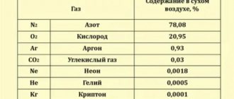
In fact, 21% of the Earth's atmosphere consists of life-giving oxygen (78% is nitrogen, and the remaining 1% is other gases). And this ratio in proportions is almost the same both at sea level and high in the mountains.
The big difference is not the amount of oxygen present, but rather its density and pressure.
Air is often compared to the ocean using the term "ocean of air", and this is true because we are all literally floating in the air. Now imagine this: a tall plastic bucket is filled to the brim with water. Now make a hole in the top of the bucket. The water will drain slowly. Now make another hole at the bottom near the bottom. What will happen? Water will rapidly flow out from the bottom hole in a strong stream. The reason is the difference in pressure. The pressure exerted by the weight of the water below at the bottom of the bucket is greater than at the top, so the water is “squeezed out” more strongly from the hole below.
Likewise, the pressure of all the air above us is the force that pushes air into our lungs, thereby delivering oxygen into the bloodstream. Once this pressure is reduced (for example, when we climb a high mountain), less air enters the lungs, therefore less oxygen reaches our bloodstream, resulting in hypoxia; again, not due to a decrease in the amount of available oxygen, but due to a decrease in atmospheric pressure.
What is atmospheric pressure?
Atmospheric pressure, also called barometric pressure, is the pressure of the gaseous shell of our planet, the atmosphere, acting on all objects located in it, as well as on the earth's surface. Pressure corresponds to the force acting in the atmosphere per unit area. In a stationary atmosphere at rest, the pressure is equal to the ratio of the weight of the overlying air column to its cross-sectional area.
Simply put, this is the force with which the air around us acts on the surface of the Earth and objects.
Atmospheric pressure is expressed in several different systems of units: millimeters (or inches) of mercury, dynes (dyn) per square centimeter, millibars (mb), standard atmosphere, or pascals (Pa). Standard sea level pressure is defined as 760 mmHg (29.92 in), 1013.25 x 103 dynes per cm2, 1013.25 millibars, one standard atmosphere, or 101.325 kilopascals. 1 mmHg corresponds to approximately 133 Pa.
Why does atmospheric pressure occur?
Many experiments have proven that air is not weightless. The Earth's gravitational force acts on the air, which contributes to the formation of pressure.
The mass of air around the globe is not the same. Therefore, the level of atmospheric pressure also fluctuates. Areas with more air mass experience higher pressure. If there is less air (in such cases it is also called rarefied), then the pressure is lower.
Why does the weight of the atmosphere change? The secret of this phenomenon lies in the heating of air masses. The fact is that the air is heated not directly from the sun's rays, but due to heating from the earth's surface. Near it, the air heats up, expands and, becoming lighter, rises. At this time, the cooled flows become heavier and go down. This process happens constantly. Air moves from areas of high pressure to areas of low pressure. The result is wind, which has a great influence on weather and climate.
What is a cyclone?
In the troposphere (lower atmospheric layer), atmospheric vortices constantly appear and disappear.
Many of them are quite small, but some are enormous in size and reach several thousand kilometers in diameter. If such a vortex moves counterclockwise in the northern hemisphere or clockwise in the southern hemisphere, and there is an area of low pressure inside, then it is called a cyclone. It has a colossal supply of energy and leads to negative weather phenomena such as thunderstorms, strong winds, and squalls.
Depending on where they form, cyclones are classified as tropical or extratropical. The first ones appear in tropical latitudes and are small in size (several hundred kilometers in diameter). At their center there is usually an area with a diameter of 20–25 km with sunny weather, and storms and winds rage at the edges.
Extratropical cyclones, formed in polar and temperate latitudes, reach gigantic sizes and simultaneously cover large areas of the earth's surface. They are called differently in different areas: in America - hurricane, in Asia - typhoon, and in Australia - willy-willy. Each powerful cyclone gets its own name, for example Katrina, Sandy, Nancy.
Atmospheric pressure measurement
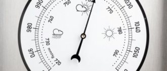
To measure atmospheric pressure, meteorologists use a barometer.
There are two types of barometers:
- liquid;
- mechanical (aneroid barometer).
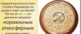
Liquid barometers are filled with mercury. This device was invented by the Italian scientist Evangelista Torricelli. In 1643 he proved that the atmosphere could be weighed using a column of mercury. This device was the very first barometer. The open end of the glass tube is placed in an open bowl of mercury. Atmospheric pressure forces the mercury to rise up the tube. At sea level, the mercury will rise (on average) to a height of 760 millimeters.
Why not use water instead of mercury? The fact is that mercury is 13.6 times denser than water. Atmospheric pressure can hold in place a vertical column of water approximately 13.6 times higher than mercury. And in order to make a water barometer, you will need a glass tube more than 10 m long!
Evangelista Torricelli - Italian mathematician and physicist, student of Galileo. Known as the author of the concept of atmospheric pressure and the successor of Galileo's work in the development of new mechanics.
On the other hand, mercury is the heaviest substance that remains liquid at ordinary temperatures. This makes the tool more convenient to use.
Aneroid barometers are more common . The design of such a device includes a metal box with rarefied air inside. When the pressure drops, the box expands. As the pressure increases, the box compresses and acts on the attached spring. The spring moves the arrow, which shows the pressure level on the scale.
Increase and decrease in pressure
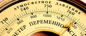
When the pressure exceeds 760 mmHg. Art., it is called elevated, and when the level is less than normal - reduced.
Over the course of 24 hours, several changes in atmospheric pressure occur. In the morning and evening it rises, and after 12 noon and at night it decreases. This occurs due to the fact that the air temperature changes and, accordingly, its flows move.
In winter, the highest atmospheric pressure is observed over the mainland of the Earth, because the air here has a low temperature and is very dense. In summer, the opposite situation is observed - there is minimal pressure.
On a more global scale, pressure also depends on temperature. The Earth's surface heats unevenly: the planet has a geoid (rather than perfectly round) shape and revolves around the Sun. Some parts of the planet are heating up more, others less. Because of this, atmospheric pressure is distributed zonally over the surface of the planet.
Atmospheric pressure belts
There are 3 zones where low pressure prevails, and 4 zones where high pressure prevails. The equatorial zone warms up the most, so light warm air rises and low pressure forms at the surface.
At the poles, the opposite is true: cold air settles down, so high pressure is recorded here. If you look at the pattern of pressure distribution over the surface of the planet, you will notice that belts of low and high pressure alternate.
In addition, you need to remember about the uneven heating of both hemispheres of the Earth throughout the year. This leads to some displacement of the low and high pressure belts. In summer they move to the north, and in winter - to the south.
Atmospheric pressure normal for humans
Normal atmospheric pressure is 760 mmHg. Art. or 101,325 Pa at 0 ℃ at sea level (45° latitude). In this case, each square centimeter of the earth's surface is affected by the atmosphere with a force of 1.033 kg. A column of mercury 760 mm high balances the mass of this column of air.
Almost all of the Maldives, an island nation in the Indian Ocean, is located almost at sea level. This makes the Maldives the "lowest-lying" country in the world, under constant threat from rising sea levels. The country hopes to buy land in India, Sri Lanka or Australia to be able to evacuate residents of the Maldives if the islands begin to go under water.
The aforementioned Torricelli also noticed during the experiment that when the flask is filled with mercury, an unfilled space remains in its upper part - emptiness. Over time, this phenomenon began to be called “Torricelli void.” Then the scientist did not yet know that during his experiment he created a vacuum - that is, a space free of any substances.
At a standard pressure of 760 mmHg. Art. the person feels most comfortable. The air presses on a person with a force of about 16 tons, but we do not notice it. Why don't we feel this pressure?
The fact is that there is pressure inside our body too. Not only people, but also representatives of the animal world have adapted to atmospheric pressure. Each organ was formed and developed under the influence of this force. When the atmosphere acts on a body, this force is evenly distributed over the entire surface. Thus, our internal pressure is balanced with external pressure, and we do not feel it.
Normal atmospheric pressure should not be confused with climate norm. Each region has its own standards for a certain time of year. For example, in Vladivostok, the average annual atmospheric pressure is almost equal to the norm - 761 mm Hg. Art.
But in settlements located in mountainous areas (for example, in Tibet), the pressure is usually much lower - 413 mm Hg. Art. This is associated with an altitude of about 5000 m.
Panoramic view of the city of Puno next to Lake Titicaca, in the Peruvian Andes, near Bolivia. Puno is the capital of the province of Puno with a population of approximately 150,000 people. The city is located at an altitude of 3812 meters above sea level. Atmospheric pressure at this altitude is about 483 mmHg.
Art.
1. Let us now consider maps of long-term average sea level pressure in January and July. Zonal features in pressure distribution can be easily seen on these maps. However, the influence of the uneven distribution of land and sea leads to the fact that in each zone the pressure field breaks up into separate cells, into areas of high and low pressure with closed isobars. These areas are called centers of atmospheric action. Some centers of action can be found on climatological maps of all months of the year; these centers are called permanent. Others are found on maps of only winter or only summer months; they are called seasonal centers of action.
2. January. Map XXIX clearly shows the equatorial depression with pressure below 1015 hPa. Within this depression there are three distinct areas of low pressure with closed isobars: over South America, South Africa and Australia and Indonesia. The pressure in the centers of all areas is below 1010 hPa. The areas with the lowest pressure in the equatorial depression are located in January not at the equator itself, but rather far from it: approximately 15° south. sh., over the warmed (summer here!) continents of the southern hemisphere.
On both sides of the equatorial depression, subtropical high pressure zones are found, which consist of several anticyclones with closed isobars. Such anticyclones are especially well pronounced over all three oceans of the southern hemisphere (with centers at 30-35° S and with pressure in the center above 1020 hPa); over continents that are warmer than the oceans, they are replaced by low pressure. In the northern hemisphere, subtropical anticyclones are found over the Atlantic and Pacific oceans (closed isobars at 1020 hPa), where their centers are also located at 30-35° latitude. The anticyclone over the North Atlantic Ocean is called the Azores, over the North Pacific Ocean - the Honolulu or Hawaiian.
Over Asia in subtropical and tropical latitudes the pressure is also increased. However, there is no independent subtropical anticyclone here: South Asia is occupied by the southern part of the huge Asian winter anticyclone centered in Mongolia.
In the temperate and subpolar latitudes of the southern hemisphere, south of the subtropical anticyclones, there is an almost continuous zone of low pressure, in which, however, several centers can be distinguished. At corresponding latitudes in the northern hemisphere, low pressure is found only over the oceans.
These are two oceanic depressions: the Icelandic in the north Atlantic Ocean and the Aleutian in the north Pacific Ocean with a pressure in the center below 1000 hPa. Over the continents of Asia and North America they are replaced by winter anticyclones: the Asian one, which has already been mentioned, and the Canadian one. In the Asian anticyclone, the pressure in the center is above 1035 hPa, in the Canadian anticyclone it is above 1020 hPa.
In polar latitudes, pressure is increased compared to subpolar latitudes. The high pressure area over Antarctica is especially well defined: the Antarctic anticyclone. In the northern hemisphere, the increase in pressure in the Arctic basin is insignificant. Only over icy Greenland is a closed isobar with a value of 1000 hPa visible, outlining an area of relatively high pressure.
3. July. Map XXX shows that the equatorial depression in July shifted to the north and the lowest pressure in it is no longer in the southern hemisphere, but in the northern hemisphere, where it is now summer. The low pressure centers over the warmed continents of the northern hemisphere have moved particularly far north: they are located around the 30th parallel in both Asia and North America. These parts of the equatorial depression, which extend over the heated continents even beyond the tropics, are called summer depressions: South Asian and Mexican.
High pressure zones in the subtropics are also visible. In the southern hemisphere, where it is winter in July, subtropical anticyclones capture not only the three oceans in the subtropics and tropics, but also the continents, which are now cold. But in the summer northern hemisphere, anticyclones remain only over two oceans (and, as can be seen from the maps, they move further north and even intensify). Over the continents of subtropical latitudes, the pressure, in contrast to January, as we have seen, is lower.
It remains low at higher latitudes. Thus, in the temperate and subpolar latitudes of the northern hemisphere, oceanic depressions (much less deep than in winter) and depressions over the continents form a continuous subpolar zone of low pressure around the entire hemisphere. To the north of it, the pressure increases slightly.
In the southern hemisphere in July, as in January, there is a low pressure zone in subpolar latitudes and an anticyclone over the Antarctic continent.
So, the zonality in the distribution of pressure is violated by the fact that the pressure over the continents increases in winter and decreases in summer. In winter, high pressure over the continents is found even in temperate and subpolar latitudes, where it is generally lower. In summer, over the continents, pressure decreases even in subtropical zones, where it is generally increased.
Map XXIX. Distribution of mean atmospheric pressure at sea level in January (hPa).
Card XXX. Distribution of mean atmospheric pressure at sea level in July (hPa).
Map XXXI. The average absolute height of the isobaric surface is 300 hPa in December-February. Heights in geopotential decameters.
Map XXXII. The average absolute height of the isobaric surface is 300 hPa in June-August. Heights in geopotential decameters.
4. The presence of centers of action on long-term average maps indicates that the same stable cyclone or anticyclone is located in certain places on the Earth all year round or throughout the entire season. In reality, cyclones and anticyclones in the atmosphere alternate quite quickly. It follows from climatological maps that in some places on the Earth cyclones prevail over anticyclones, and therefore centers of action with low pressure are outlined on the maps there (as, for example, in the north of the Atlantic Ocean - the Icelandic depression). In other places, anticyclones are observed much more often than cyclones, and therefore centers of action with high pressure are indicated on maps (like the Azores anticyclone in the subtropics of the Atlantic Ocean). In fact, at one time or another, for example, not one, but two subtropical anticyclones can be observed simultaneously over the North Atlantic Ocean, and even three over the North Pacific Ocean.
5. Previously, it was believed that in the polar regions anticyclones persist almost constantly, or, in any case, they prevail over cyclones so much that on long-term average maps there should be quite strong centers of action with high pressure - polar anticyclones. It is now known that in the Arctic the predominance of anticyclones over cyclones is very small, and therefore the Arctic anticyclone is outlined very poorly on long-term average maps. And over Antarctica, anticyclones do not have such exceptional constancy. But still, the Antarctic anticyclone is, on average, much better expressed than the Arctic anticyclone. The issue is particularly complicated by the high altitude of the continent of Antarctica itself above sea level at very low surface air temperatures above the icy surface. Adjusting pressure to sea level gives inflated results that are incomparable with sea level pressure values for the ocean and lowlands. In order to see how much higher the pressure over Antarctica is than over the surrounding ocean, it is necessary to draw maps not for sea level, but for a level of 3-4 km, close to the surface of the continent (for an isobaric surface of 700 hPa). Average monthly maps for the 700 hPa surface reveal the presence of an anticyclone over East Antarctica in all months of the year.
6. On long-term average maps of pressure topography for surfaces of 700, 500, 300 hPa, etc., it is clear that with height there are fewer and fewer closed isohypses outlining individual centers of action, and the pressure distribution becomes more and more zonal (maps XXXI, XXXII) . This is understandable, since with altitude the influence of the distribution of land and sea on temperature, and consequently on pressure, weakens. In the upper troposphere and lower stratosphere, absolute isohypses on average maps, and therefore isobars, circle the entire globe, of course not coinciding quite exactly with the latitudinal circles; at the same time, they bend somewhat towards low latitudes over warm continents. Only near the equator are individual anticyclones still found, even in the upper troposphere. So, the highest pressure will be near the equator, the lowest - over the polar region. True, in winter in the northern hemisphere the lowest pressure is shifted from the pole to the especially cold northeastern parts of Asia and North America.
In layers above 20-25 km in summer, the pressure distribution changes radically due to changes in the meridional temperature distribution. Above the pole, the pressure becomes increased, i.e., the circumpolar depression is replaced by an anticyclone.
Read more about meteorology and climate...
| Favorite Color Foam | Washing railway cars | Favorite Active Foam | Favorite Test, Ultra | Cleaning injectors | Boat washing |
The influence of atmospheric pressure on humans
For a long time, medicine did not recognize the connection between weather events and health. Only over the past 50 years, thanks to a comprehensive study of the influence of weather conditions on the human body, it has been proven that atmospheric pressure and human health are closely related, and people react to any weather changes with complications in their well-being. The situation when weather conditions affect the physical state of the human body is called meteopathy.
Meteopaths are people whose body reacts to even minimal deviations of atmospheric pressure from the norm. They also include people with certain chronic diseases (in particular, cardiovascular, nervous system, etc.).
The atmospheric pressure fluctuates within 30 mm Hg per year. Art. During the day, values can fluctuate from 1 to 3 mmHg. A healthy person does not feel these changes, but weather-dependent people with any health problems can feel these deviations.
Hypertension and hypotension are two main diseases characterized by meteorological dependence.
High atmospheric pressure is extremely unsafe for hypertensive patients and people with heart disease. Anyone who has hypertension and sensitivity to weather changes will have to deal with the following symptoms: the heart beats faster, against the background of which blood pressure (BP) rises; the skin begins to turn red; weakness is observed; There is noise in the ears, spots in front of the eyes, and pulsation in the head.
People with hypertension in old age feel strongly the weather changes. Their body is weakened by age-related changes and accumulated diseases, resulting in a risk of hypertensive crisis, damage to the heart and blood vessels.
A drop in atmospheric pressure primarily affects the health of people with hypotension and respiratory pathologies. The percentage of carbon dioxide in the air increases, and oxygen, on the contrary, decreases. Such changes in weather conditions due to a lack of oxygen in hypotensive patients cause ailments: blood circulation slows down and the pulse weakens, blood flows worse to the organs, blood pressure drops; breathing becomes difficult; drowsiness and fatigue, dizziness and nausea appear; intracranial pressure increases, against the background of this, spasms occur that turn into headaches.
The dependence of people’s well-being on atmospheric pressure concerns not only surges in blood pressure. In people with mental disorders, the manifestation of obsessive states, fears and various phobias increases.
With joint diseases, the likelihood of pain attacks increases at the sites of fractures and where problems exist.
Absolutely anyone, even a healthy person, will feel significant deviations from the norm. This applies to both high and low pressure.
The effect of low atmospheric pressure on the well-being of a person located, for example, in the mountains, is manifested in increased breathing and heart rate, headaches, asthma attacks and nosebleeds. Symptoms disappear as the person gets used to the surrounding conditions. There is often a need for medical care for people who have signs of oxygen deprivation.
Climbers, when climbing mountain peaks, are forced to take oxygen cylinders with them in order to avoid death from lack of oxygen.
Climbing Everest
With elevated blood pressure, a person's pulse slows down and respiratory function is inhibited. In addition, blood clotting increases and intestinal walls contract. The influence of external pressure on a person’s well-being increases in proportion to the distance to which the person descends. People who work at depth are most susceptible to the effects of high pressure. The amount of dissolved gases in the blood reaches its maximum value, performance and concentration increase. However, at the same time, a large amount of oxygen has a toxic effect and provokes the occurrence of lung diseases. Raising workers from depth is carried out in a special way in accordance with accepted techniques. If the rate of ascent is disrupted, gas bubbles clog the blood vessels and death can occur.
The influence of hell vibrations on the human body
Since balance is achieved through the fluids of our body - blood, lymph, tissue fluid - atmospheric pressure directly affects blood pressure. Changes in one lead to imbalance in the other.
Low barometer reading
A decrease in pressure, which is observed when rising to a height, can lead to the following consequences:
- labored breathing;
- low heart rate;
- fatigue, drowsiness;
- apathy;
- low blood pressure;
- headache;
- attacks of dizziness;
- nausea or vomiting;
- digestive system disorders;
- problems with concentration.
When air pressure decreases, people with respiratory pathologies and usually low blood pressure are at risk. Usually their condition gets worse under such conditions. If a person does not feel changes, such fluctuations can be considered normal for him.
High barometer reading
Fluctuations upward in the mercury column are observed when descending into mines, caves or other lowlands.
Discomfort will differ from low blood pressure:
- ringing in the ears, stuffy ears;
- pulsation in the temples and neck;
- increased blood pressure;
- increased heart rate;
- rush of blood to human skin, redness;
- spots before the eyes;
- headache:
- dizziness;
- nausea or vomiting.
Note!
With elevated atmospheric pressure, heart attacks and strokes often occur. People prone to weather dependence should monitor weather conditions and on days of high blood pressure not overload their body with stress or physical activity.
At-risk groups
If the mercury moves even one division in 2-3 hours, weather-dependent people will feel it. Fatigue, drowsiness, nausea and other unpleasant or even painful symptoms will immediately manifest themselves. Who are classified as people dependent on changes in atmospheric pressure?
Various injuries, diseases or congenital pathologies are the cause of such unpleasant symptoms. So the people who suffer from weather dependence first of all are:
- with high or low blood pressure;
- with respiratory pathologies - asthma, bronchitis, pleurisy, chest injuries, sinusitis, sinusitis;
- with musculoskeletal disorders - arthrosis, osteochondrosis, old injuries;
- with ear diseases;
- after traumatic brain injury or with increased intracranial pressure.
What to do to relieve symptoms
It is very important for middle-aged and older people to take care of their health. Cyclones and anticyclones can cause serious consequences.
To prevent stroke and heart attack, as well as alleviate unpleasant symptoms, you should listen to some tips:
- Consultation with your doctor. He, based on the patient’s characteristics, will be able to select the right drug or, for example, treatment in an oxygen pressure chamber.
- Regularly checking weather conditions. It is necessary to free such days from stress at work and at home.
- Correct sleep schedule. Sleep duration should be at least 7 hours. When the weather changes, it is better to go to bed earlier.
- Proper nutrition. The menu should be balanced and complete. Eliminate fatty foods, but consume foods containing omega 3-6-9 acids.
- Walks in the fresh air (preferably in the evening).
- Moderate physical activity.
- Reduced stress levels.
Cyclones and anticyclones
There are two main types of pressure systems in the atmosphere: cyclones and anticyclones. Cyclones and anticyclones are wind systems that have opposite characteristics.
A cyclone is a collection of winds circulating in a low pressure system. It rotates counterclockwise in the Northern Hemisphere and clockwise in the Southern Hemisphere. It is usually associated with wet and stormy weather.
An anticyclone is a type of wind that circulates in a high pressure system. It rotates clockwise in the Northern Hemisphere and counterclockwise in the Southern Hemisphere. It is usually associated with dry and clear weather.
In order to better understand how these two phenomena differ, let's look at them in more detail.
A cyclone is an area of low pressure where air masses rise. This usually indicates bad weather, such as rain or clouds. Winds in cyclones blow counterclockwise in the northern hemisphere and clockwise in the southern hemisphere. In a cyclone, air near the ground is forced toward the low-pressure center of the cyclone and then rises, expanding and cooling as it moves. As the rising air cools, it becomes more humid, leading to cloudiness and high humidity inside the cyclone. The main effects of tropical cyclones include heavy rain, strong winds, severe storm surges close to shore, and tornadoes. Destruction from a tropical cyclone, such as a hurricane or tropical storm, mainly depends on its intensity, size and location.
There are two types of cyclones:
1. Tropical cyclones . These cyclones that form over warm tropical oceans are also called tropical storms or tropical depressions. They are relatively small in size. However, they are characterized by enormous, destructive wind power.
The main tropical cyclone basins include the North Atlantic (including the Caribbean), the eastern Pacific, the western Pacific, the northern Indian Ocean, the southwestern Indian Ocean, the southern Pacific and the Australian region. Typically, tropical cyclones develop between 5 and 30 degrees latitude, as they require ocean water at a temperature of 27°C or so to form.
The terminology associated with tropical cyclones is quite confusing because people call these dangerous storms by different names in different parts of the world. In the North Atlantic and Caribbean, as well as the northeastern Pacific, they are commonly called "hurricanes." In the northwest Pacific, the most active tropical cyclone basin in the world, they are “typhoons,” while in the Indian Ocean and South Pacific they are simply “tropical cyclones” or “cyclones.” “Tornadoes”—much smaller and more localized than tropical cyclones, but capable of generating even higher wind speeds—are sometimes colloquially called “cyclones,” although they are completely different storms.
Particularly severe thunderstorms, which generate most of the world's most powerful tornadoes, form rotating updrafts called mesocyclones. In the United States, about 1,700 mesocyclones occur annually, with approximately 50 percent of them becoming tornadoes.
The birth of a huge tornado
Cyclones are among the most dangerous and destructive natural disasters that can occur. They have been responsible for 1.9 million deaths worldwide over the past two centuries. According to some estimates, up to 10,000 people die from these storms each year. Cyclones usually cause the greatest damage to coastal areas.
The consequences of Cyclone Idai - the deadliest tropical cyclone among the cyclones in the southwestern Indian Ocean that existed from March 4 to March 21, 2021. Wind gusts reached speeds of 280 km/h. The cyclone affected the states of Mozambique, Madagascar, Zimbabwe and Malawi, causing severe flooding in the affected areas, leading to numerous casualties. At least 1,297 people were killed, hundreds of thousands were left in need of assistance, and economic losses in these regions totaled more than $2 billion.
Consequences of tropical cyclone Kenneth in Mozambique. The cyclone hit northern Mozambique on April 25, 2021, with heavy rainfall and winds of up to 220 km/h. As a result of the disaster, more than 40 people died. In the Comoros Islands, the cyclone destroyed almost 80% of farms and more than 60% of crops, as well as over 3,800 houses. Previously, Mozambique was seriously affected by tropical cyclone Idai .
2. Extratropical or mid-latitude cyclones . They develop along frontal boundaries in mid-latitudes. These cyclones, which, unlike their tropical counterparts, develop where sharp temperature gradients exist between adjacent air masses, can be much larger than hurricanes, although their winds tend to be weaker. They reach several thousand kilometers in diameter.
3. Polar cyclones, also known as “Arctic hurricanes,” sometimes form over the Arctic and Antarctic seas, caused by the influence of cold air moving over slightly warmer ocean waters. In the Northern Hemisphere, meteorologists sometimes call polar cyclones “Arctic hurricanes” because their energy source is heat transfer from water to air and latent heat released by cloud condensation, and because their spiral cloud bands are somewhat similar to tropical cyclones. Polar cyclones often form quickly, sometimes in less than 24 hours, and are difficult to predict in advance.
An anticyclone is an area of high pressure where air masses descend towards the ground. This usually indicates good weather. Winds in an anticyclone blow clockwise in the northern hemisphere and counterclockwise in the southern hemisphere. Air masses in the center of the anticyclone move downwards, being replaced by a downward flow of air from high altitudes. As it moves down, the air compresses and heats up, which reduces its humidity and leads to a decrease in the number of clouds inside the anticyclone, dry and cloudless weather.
As you know, winds blow from a high pressure system to a low pressure system. In the case of an anticyclone, the wind blows and diverges from the center of the high pressure system. However, it does not flow straight out. Due to the Earth's rotation, air tends to move in a spiral. In the Northern Hemisphere, air currents in areas of high pressure move clockwise, and in the Southern Hemisphere, they move counterclockwise. This pattern ensures that winds to the east of an anticyclone in the Northern Hemisphere will bring cold air from the north, while winds to the west will bring warm air from the south. In the Southern Hemisphere this picture is reversed.
An anticyclone brings stable weather conditions corresponding to the time of year. In summer the weather is windless and hot, in winter it is frosty. It is characterized by few or no clouds.
Anticyclones form in certain areas. For example, they are most often found over large bodies of ice: in Antarctica, Greenland and the Arctic. They also sometimes appear in the tropics.
Anticyclones also carry danger and unpleasant consequences. They can contribute to fires and prolonged drought. With a long absence of wind in large cities, harmful substances and gases accumulate, which is especially important for people with respiratory diseases.
Smog in China. In some cities, it is almost impossible to go outside without a mask. The smog is even visible from space. Scientists have calculated that walking the streets without a mask is equivalent to smoking a pack of cigarettes.
An anticyclone is...
An anticyclone is an atmospheric vortex with increased air pressure in the center and winds directed from the center to the edges. Indicated by the letter B (high pressure area).
In the northern hemisphere, the air swirls clockwise, and in the southern hemisphere, counterclockwise, but in any case it descends from the upper layers of the atmosphere (mainly from the troposphere) to the surface of the earth.
The reasons for the formation of anticyclones are the same as in the case of cyclones: the collision of warm and cold air fronts. However, they are formed mostly in subtropical and polar regions.
Anticyclones move slower than cyclones (their speed usually does not exceed 40 km/h), and sometimes they can “hang” in one place for a long time, forming a stable climatic zone.
Anticyclones are divided into :
- low, where cold air currents predominate, and the area of high pressure ends at an altitude of about 1.5 km;
- high, where warm air currents predominate, and the area of high pressure extends throughout the troposphere (up to 16 thousand km).
An anticyclone is characterized by clear, dry and windless weather . In summer it gets hot, in winter it gets cold.
At the same time, there is a sharp change in air temperature throughout the day, especially in the interior of the continental part. It happens that the difference between day and night values reaches 20 degrees Celsius (in Siberia this is not so uncommon).
A record drop of 55.5 C was recorded in January 1916 in Browning (Montana, USA), where the temperature dropped from +6.70 C to -48.80 C during the day.
How does atmospheric pressure change with altitude?
Atmospheric pressure is directly related to altitude. The higher, the lower the pressure and vice versa. If you rise 12 m above sea level, the mercury column in the barometer will decrease by 1 mm.
Near the Earth's surface, pressure decreases with height at a rate of about 3.5 millibars for every 30 meters. However, in the case of cold air, the decrease in pressure can be much faster because its density is greater than that of warmer air.
At sea level, the atmospheric pressure is about 1000 mb (100 kPa). At the summit of Everest (8848 meters) the pressure drops to about 300 mb (30 kPa).
The pressure at an altitude of 270,000 meters is 10-6 mb, which is comparable to the pressure in the best vacuum ever artificially created by man. At altitudes between 1,500 and 3,000 meters the pressure is so low that it can cause altitude sickness and serious physiological problems if careful acclimatization is not undertaken.
Pressure is most often displayed in hectopascals (1 hPa = 102 Pa) rather than in millimeters of mercury: 1 mmHg. Art. = 133.3 Pa = 1.333 hPa. The relationship between height and pressure is easy to obtain using a simple formula:
∆h /∆P = 12 m/mm Hg. Art. or ∆h/∆P = 9 m/hPa,
where ∆h is the change in height,
∆P - change in pressure.
Thus, with an increase of 9 meters, the pressure level decreases by 1 hPa (100 Pa). This indicator is called the pressure level. Standard atmospheric pressure is 1013 hPa (can be rounded to 1000).
How to calculate the change in pressure at a different altitude using this data? For example, when rising 90 m, the pressure will decrease by 10 hPa. In this case, it turns out that when ascending 900 m, the pressure will drop to 0.
But, since air density also changes with altitude, when it comes to greater distances (starting from 1.5-2 km), all calculations must be carried out taking this parameter into account.
Height versus pressure graph
A graph of changes in atmospheric pressure with altitude clearly displays all of the above. It looks like a curved line rather than a straight line. Due to the fact that the density of the atmosphere is not the same, with increasing altitude the pressure begins to decrease more and more slowly. However, it will never reach zero, because there is a certain amount of particles of matter everywhere - there is no absolute vacuum in the Universe.
Comparison of features of atmospheric vortices
Cyclones and anticyclones have differences and similarities. Their similarities are:
- vortex structure;
- important role in weather formation over large regions.
The appearance of an anticyclone is influenced by the formation of cyclones nearby - excess air emitted by a low-pressure vortex accumulates and provokes the development of an area of high pressure, anticyclones.
The differences between atmospheric vortices are presented in the table of comparative characteristics:
| Cyclone | Anticyclone | |
| Place of formation | More often over the oceans, it can form everywhere except the equatorial region, where the Coriolis force associated with the rotation of the Earth does not act | In the tropics, over oceans and over ice fields |
| Size (diameter) | 300-5000 km. | Up to 4000 km. |
| Movement | Constant, speed 30-60 km/h, tropical storm typhoons are much faster | Inactive or has a speed of 20-40 km/h |
| Pressure | In the center it is low, at the periphery it is high | High in the center, low in the periphery |
| Direction of rotation | In the Northern Hemisphere they rotate counterclockwise, in the Southern Hemisphere they rotate counterclockwise. | In the Northern Hemisphere the rotation is clockwise, and vice versa in the Southern Hemisphere. |
| Brings the weather | Wind, clouds, precipitation | Clear or partly cloudy, calm, no precipitation |
On synoptic maps, letters are used to designate cyclones and anticyclones: H - means an area of low pressure, B - an area of high pressure.
Rice. 3. Synoptic map.
Atmospheric pressure in the mountains
In the mountains, the atmospheric pressure will somehow be lower than at the edge of the sea. How a person will feel depends on the altitude and some additional conditions. For example, with normal humidity, climbing 3000 m can cause weakness and decreased performance. This occurs due to lack of oxygen.
In a humid climate, such sensations arise already at an altitude of 1000 m. The fact is that water molecules displace oxygen molecules - there is less oxygen in humid air. And in a dry climate you can climb 5000 m with almost no problems.
The temperature and pressure of the earth's atmosphere change with altitude. Temperatures, indicated by the yellow line, fall with altitude in some zones but rise in others. The pressure, indicated by the black line on the right, decreases greatly with altitude. Encyclopædia Britannica, Inc.
The influence of different altitudes on humans:
- 5 km - there is a lack of oxygen;
— 6 km is the highest altitude at which permanent human settlements exist;
— 8.9 km — the height of Everest. Water at this altitude boils at a temperature of + 68 ℃. Experienced, trained climbers may not be able to stay at this altitude for long;
- 13.5 km - you can only be safe here with a supply of pure oxygen. This is the maximum permissible height at which you can be without special equipment;
— 20 km is a height unacceptable for humans. It is safe only if you are in a hermetically sealed cabin.
A climber stands on the top of Mount Everest, Nepal. Mount Everest is so high that the amount of oxygen there is too low for breathing. Many climbers need oxygen tanks to reach the summit safely.
Atmospheric pressure today: